Ancient → Modern · Indian Thought
The History of Velimela
An inscription from 1121, wells dug in 1319, and a name on an 1842 map: what the records still keep about the village I moved into.
On this page
- The first trace goes back more than 900 years
- Then, in 1319, someone built wells
- Then a young surveyor enters the story
- Yellamulla
- And then the name starts moving
- Velimela in 1961
- The people who leave traces
- The strange thing about living on top of history
- There is still one question I really want answered
- Sources
I moved here. Then I started wondering how long everyone else had been here.
There is no grand reason I started looking into Velimela’s history.
I moved here. That is pretty much it.
I was already spending an unreasonable amount of time with old maps, inscriptions and records of places around Hyderabad. Once you start doing that, familiar names begin behaving strangely. Patancheru becomes Pottalakere. Tellapur turns up as Telumganapura. Places that look like modern suburbs suddenly have histories going back several hundred years.
So naturally, at some point I wondered about the place I now live in.
Velimela.
The name sounds like one of the many villages Hyderabad has recently swallowed on its western edge. Drive through the older part of the village, though, and it does not quite feel new. There are old temples, old settlement patterns, fields that survived until very recently, and the general feeling that this place was here long before the apartment towers arrived.
So I started digging. Because why not.
The first trace goes back more than 900 years
The Archaeological Survey of India’s Indian Archaeology 1986-87: A Review contains a small entry titled “Inscriptions, Elmel, District Medak.”
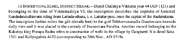
It describes two inscriptions found here.
The older one is dated Chalukya-Vikrama year 44, which corresponds to 1121 CE, in the reign of the Western Chalukya ruler Vikramaditya VI. It records the exploits of a general styled Gandadandadhisvara, ruling from Lattada-sthana, identified with Lattalur-pura, once a capital of the Rashtrakutas. It then refers to a gift, the details of which are lost, to the god Tribhuvanamalla Gundesvara for daily rites, placed in the custody of Jnanesvara Pandita.
The date falls in the last years of Vikramaditya VI, when the Western Chalukyas were pressing east toward Vengi, near today’s Pedavegi in Eluru district. Was this general moving through our part of the Deccan as part of that wider campaign? It is tempting to imagine so, and the record does not say.
Even without that connection, the entry gives us something remarkable: an inscription dated 1121 was found at Velimela. That is the earliest trace I have found so far of this place entering the historical record.
Then, in 1319, someone built wells
The second inscription belongs to the reign of Prataparudra of the Kakatiya dynasty. It is dated Saka 1241 and Kaliyugabda 4420, which works out to 28 November 1319.
Its subject is wonderfully ordinary. Someone named Gangisetti had wells constructed in the village.
Kings come and go in history books. Dynasties fight wars. Capitals move. But someone still had to build the well.
There is something I like about that. Seven hundred years ago, while Prataparudra ruled the Kakatiya kingdom, somebody here was worrying about water. Some things about this part of the world have clearly not changed.
There is, however, an important distinction. The archaeological report calls the findspot Elmel, but the published summary does not tell us that the 1121 inscription itself called the village Elmel, or anything else. The 1319 summary says wells were constructed “in the village,” without giving us the village name from the inscription.
So the evidence tells us that inscriptions of 1121 and 1319 were found here. It does not yet tell us what the people living here called the place.
Then a young surveyor enters the story
By the early nineteenth century, the East India Company’s surveyors were systematically mapping the Nizam’s Dominions. One of them was Henry Morland.
Morland was born in 1803, the son of James Morland, a coal merchant from Deptford. He entered the Madras Infantry as an ensign in 1821, when he was still very young, and joined the Hyderabad Survey as an assistant in 1828.
The Hyderabad Survey had not had an easy run before him. An assistant died in 1819. James Garling, who had led the survey, died in Hyderabad in 1820. Peter Conner arrived from Travancore and died within a month. Robert Young took over and died in 1823. Webb later went on sick leave.
This was also the era of the first cholera pandemic, which had reached Hyderabad by 1818. Garling’s death has been identified as cholera. I have not found evidence that the other survey deaths were caused by the epidemic, so it would be wrong to attribute them all to it.
But it does change how I picture these maps. Today I can zoom into an old image on a laptop. The people who gathered the information behind it were travelling across the Deccan on horseback and on foot, through heat, monsoon, disease and terrain their own administration was still trying to understand.
In July 1829, James Webb went on sick leave. On 1 August 1829, Morland took charge of the Hyderabad Survey. He was about twenty-five years old.
By October that year his teams were at work in the Medak country, and the Medak survey belongs to 1829 and 1830. They measured distances and angles, traced roads and streams, marked tanks and hills, and wrote down the names of villages as they heard them.
One of those villages appears to have been mine.
Yellamulla
The surviving Indian Atlas map was published later. Sheet 75 was issued in 1842, and the British Library catalogue dates its publication to 1 June 1842.
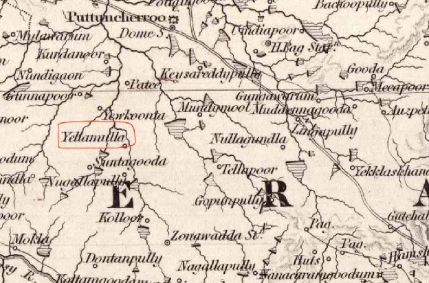
Zoom into the countryside west of Hyderabad and familiar places begin appearing. Puttuncherroo is Patancheru. Tellapoor is Tellapur. Kolloor is Kollur. And in the middle of them, where Velimela sits today, the sheet reads Yellamulla.
The modern village is there, just under another name.
Yellamulla was probably recorded during the Hyderabad Survey around 1829 and 1830, and the earliest dated map I have found showing it was published in 1842. That makes this the oldest cartographic record of Velimela I have. So far.
And then the name starts moving
Once Yellamulla appeared, later maps suddenly made more sense.
On a Survey of India map from 1916-17, the village appears as Elimala. A few records use Elmela, Elmel or Velmula. These are different attempts to write down the same old spoken place-name.
But I do not yet know the actual linguistic path. How did this name come about, and how did it change?
That is probably the most interesting part of this whole exercise. An old map answers one question and creates five new ones.
Velimela in 1961
The next record gives us something maps cannot. People.
The 1961 Census of India, in its volume on fairs and festivals in Medak district, has an unusually detailed entry for Elmela. Population: 1,543. The principal occupations were agriculture and agricultural labour.
The census lists temples dedicated to Anantha Padmanabhaswamy, Edamma, Durgamma, Hanuman, Pochamma, Beerappa, Mallikarjuna and Rameswaraswamy.
The Anantha Padmanabhaswamy temple comes with a story. According to information supplied to the census by Sri Nagaiah, the village Patwari, about 150 years earlier a man named Venkata Reddy, described as a devotee of Ananthaswamy of Anantagiri near Vikarabad, had enshrined an image of Ananthaswamy at Elmela. The census says the annual festival had been celebrated ever since. A recent video shows it still being celebrated today.
“One hundred and fifty years ago,” recorded in 1961, takes the tradition back to roughly the early 1800s. Which is fascinating, because that is almost exactly the period when Morland’s surveyors were arriving with their instruments and writing Yellamulla on their maps.
One record comes from government surveyors. The other comes from village memory. Both point toward the same landscape in the early nineteenth century.
The census also describes a four-day Anantha Padmanabhaswamy festival, with kalyanam, rathotsavam and chakrateertham, and says a fair associated with the temple had itself been running for around 150 years. About 500 people from Elmela and neighbouring villages attended.
Suddenly the dot on the 1842 map becomes easier to imagine. Not just Yellamulla. A village. Fields. Wells. A temple. A yearly fair. People travelling in from nearby settlements.
The people who leave traces
What I like most about this story is that it is not really a story of kings. It is a story of people who happened to leave small traces behind.
In 1121, a general enters the record. In 1319, Gangisetti builds wells. In the early 1800s, according to village memory recorded by the census, Venkata Reddy installs Anantha Padmanabhaswamy. Around 1829, Henry Morland, a young military officer who had barely begun his surveying career, is suddenly responsible for mapping Medak. In 1961, Nagaiah the Patwari tells the census officer what the village remembers.
And now, two centuries after Morland’s survey party passed through, I am looking at those same names on a screen and trying to connect them.
That is probably the part of history I enjoy most. Not just what happened, but who happened to be there.
The strange thing about living on top of history
Today, Velimela is part of Hyderabad’s western growth corridor. Roads are widening. Fields are disappearing. Apartment towers are rising. Places that were separate villages within living memory are slowly becoming neighbourhoods of one enormous city.
From that perspective, Velimela can look new.
But the records tell a very different story. An inscription dated 1121 was found here. Someone was building wells here in 1319. British surveyors came through this part of the country around 1829 and 1830. In 1961, 1,543 people lived here.
And now I live here. Which is, admittedly, the least historically significant event in that sequence. But it is the reason I started looking.
There is still one question I really want answered
What was this village actually called in 1121?
The inscription found here tells us people were here. The Kakatiya inscription tells us people were still here two centuries later. But the name disappears into silence until the nineteenth-century surveys give us Yellamulla.
Somewhere between the inscriptions, old revenue records, forgotten maps, temple records and whatever survives in local memory, there may be an answer.
Perhaps Velimela is already very old. Perhaps it replaced another name. I do not know yet.
That is also why I do not think of this as a finished history of Velimela. It is simply everything I have managed to find so far about the place I happen to call home.
And now that I know someone was building wells here in 1319, it is going to be difficult to look at the village the same way again.
Sources
- Archaeological Survey of India, Indian Archaeology 1986-87: A Review, p. 103, for the 1121 Western Chalukya inscription and the 1319 Kakatiya inscription at Elmel. PDF
- Epigraphia Telanganica, Vol. I, Government of Telangana, for the Western Chalukya context. PDF
- R. H. Phillimore, Historical Records of the Survey of India, Vol. III, for Henry Morland’s career, the Hyderabad Survey, the deaths of earlier survey officers and the Medak survey chronology of 1829 and 1830. PDF
- Indian Atlas, Sheet 75 (Hyderabad), published 1 June 1842, which shows the village as Yellamulla. British Library catalogue
- Census of India 1961, Fairs and Festivals: Medak, entry for Elmela, for the population, the temples, the Venkata Reddy tradition and the festival description. PDF
- Historical background on the late reign of Vikramaditya VI and the Western Chalukya campaigns toward Vengi was checked against published historical and epigraphic sources. The connection between the general at Elmel and those campaigns remains a possibility, not an established fact.
- Historical records of the first cholera pandemic confirm that cholera had reached Hyderabad by 1818. Garling’s death has been identified as cholera. The causes of death of the other survey officers mentioned above have not been established here.